


Le Thoronet - Pont d'Argens

soca
User
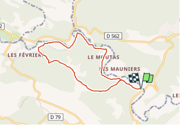

Length
8.2 km

Max alt
186 m

Uphill gradient
132 m
Km-Effort
9.9 km

Min alt
98 m

Downhill gradient
132 m
Boucle
Yes
Creation date :
2024-05-21 06:17:54.985
Updated on :
2024-05-21 06:21:51.996
2h30
Difficulty : Medium

FREE GPS app for hiking
 SityTrail
IGN / Geographical institutes
SityTrail Plus
The world is yours!
About
Trail Walking of 8.2 km to be discovered at Provence-Alpes-Côte d'Azur, Var, Le Thoronet. This trail is proposed by soca.
Positioning
Country:
France
Region :
Provence-Alpes-Côte d'Azur
Department/Province :
Var
Municipality :
Le Thoronet
Location:
Unknown
Start:(Dec)
Start:(UTM)
282521 ; 4816175 (32T) N.
Comments